


Friendly Streets
The Friendly Streets initiative by LTA is developed with the community. Building on existing efforts such as Silver Zones, School Zones and road repurposing, it aims to make daily walking journeys to key amenities in neighbourhoods safer, more convenient and comfortable.
Friendly Streets will be implemented at locations with high pedestrian flow, near key amenities such as markets, hawker centres, shopping malls, community clubs, schools, and MRT stations.

Pedestrian-friendly features that may be implemented include:
- Roads with reduced speed limits;
- More barrier-free pedestrian crossings with pedestrian priority1;
- Road markings and treatments to calm vehicular traffic and encourage gracious road behaviour; and
- Wider and more accessible footpaths where possible.
Features in each Friendly Street will be tailored to meet different needs of each area to create more inclusive neighbourhoods and gracious communities.
Selected signage in Friendly Streets, such as at the entrances and before crossings, will feature this logo, to signal to motorists slow down and be mindful of other road users, especially seniors and children crossing the roads, as they are entering a pedestrian-friendly environment.
1 - For signalised crossings, Green Man at these crossings will be activated more quickly and give pedestrians more time to cross the road.
Pilots
LTA first introduced the Friendly Streets initiative in five pilot towns - Ang Mo Kio, Bukit Batok West, Tampines, Toa Payoh and West Coast.
Five Pilots
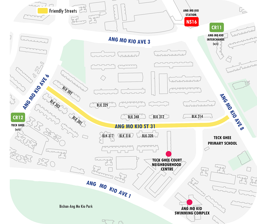
Ang Mo Kio

Ang Mo Kio Street 31 is the first completed Friendly Streets pilot. It serves residents going to amenities such as Teck Ghee Court Neighbourhood Centre, Teck Ghee Primary School, and transport nodes such as Ang Mo Kio station and upcoming Cross Island Line (CRL) stations in the vicinity.
The new raised zebra crossing between Blocks 318 and 348 and new barrier-free kerbless crossings provide safer pedestrian connectivity.
View the Location Map of Ang Mo Kio Friendly Street (PNG, 256kB)
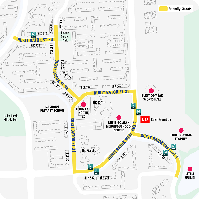
Bukit Batok West

Bukit Batok West Avenue 5, Bukit Batok East Avenue 5 and Bukit Batok Streets 31, 32 and 33 are the key corridors surrounding and leading to key amenities such as Hong Kah North Community Club, Bukit Gombak Neighbourhood Centre, Bukit Gombak Sports Hall & Stadium and Bukit Gombak station.
Residents can now enjoy safer and more convenient commutes with features such as additional barrier-free kerbless crossings and new signalised pedestrian crossings at the junction of Bukit Batok Street 31/32.
View the Location Map of Bukit Batok West Friendly Streets (PNG, 396kB)
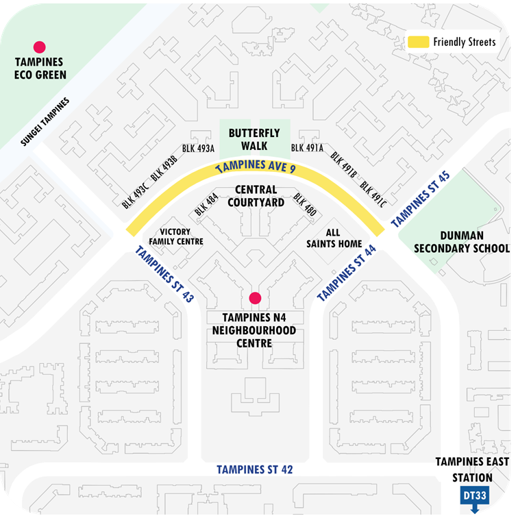
Tampines

The Tampines Avenue 9 Friendly Street serves residents going to the N4 Neighbourhood Centre, Victory Family Centre, All Saints Home, and Tampines East station.
Residents can enjoy the upgraded and relocated bus stop in front of Block 484 and more barrier-free crossings, such as the new kerbless crossing between the Neighbourhood Centre (Central Courtyard) and Residential Cluster (Butterfly Walk).
View the Location Map of Tampines Friendly Street (PNG, 215kB)
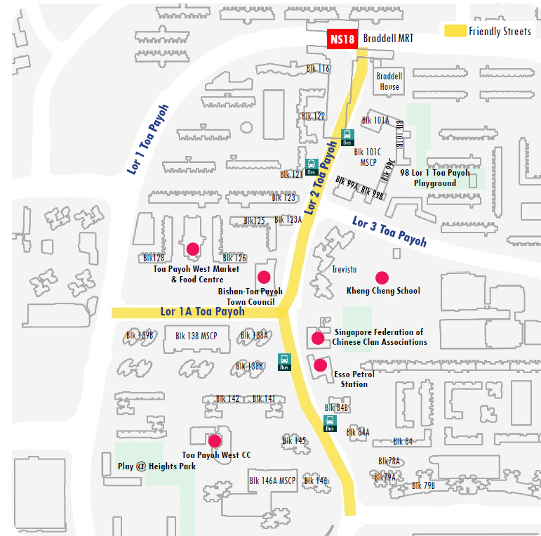
Toa Payoh

The Toa Payoh Friendly Street covers a stretch of Lorong 2 and the entire Lorong 1A, serving residents going to the Toa Payoh West Market & Food Centre, Toa Payoh West CC, as well as Braddell station.
Residents can now enjoy more barrier-free crossings, as well as the upgrading of existing bus stops along Lorong 2.
Wider footpaths also allow for more accessible and comfortable pedestrian movement.
View the Location Map of Toa Payoh Friendly Streets (PNG, 312kB)
West Coast

The West Coast Road Friendly Street covers the stretch between Clementi Avenue 2 and West Coast Link, serving residents going to the West Coast Market & Food Centre, West Coast Plaza, West Coast Community Club, schools (such as Grace Orchard School and Kent Ridge Secondary School) and Clementi Woods Park.
Pedestrians can have a safer and more comfortable journey along the Friendly Street, thanks to bus-friendly humps and the upgrading of existing bus stops in front of West Coast Market & Food Centre.
View the Location Map of West Coast Friendly Streets (PNG, 465kB)
Upcoming Friendly Streets
The next batch of 10 Friendly Streets will progressively begin construction works in 2025.
Bedok

The Friendly Street at Bedok North Street 2 will serve residents going to amenities such as Fengshan Community Club, Bedok Sports Complex, and Bedok 85 Market & Food Centre.
Residents can look forward to more barrier-free kerbless crossings with wider centre medians, traffic calming measures like speed humps and green coloured road surfaces, and longer Green Man crossing times at signalised pedestrian crossings.

New barrier-free kerbless crossings with wider centre medians will make it easier and safer for pedestrians to cross the road.

Street signs and green road surface markings will remind motorists to slow down when entering and driving along the Friendly Street.
Buangkok

The Friendly Street at Buangkok Crescent will serve residents going to amenities such as Buangkok Square Mall and parks and shops in the neighbourhood.
Residents can look forward to more barrier-free kerbless crossings with wider centre medians, traffic calming measures like green-coloured road surfaces, and longer Green Man crossing times at signalised pedestrian crossings.

A new raised zebra crossing will make it easier and safer for pedestrians, especially young children and seniors, to cross the road.

Street signs and green road surface markings will remind motorists to slow down when entering and driving along the Friendly Street.
Bukit Panjang

The Bukit Panjang Friendly Streets will cover Pending Road, Bukit Panjang Ring Road, and Bangkit Road. New barrier-free crossings, road humps and pedestrian priority with longer crossing time at signalised pedestrian crossings will make it more convenient for residents visiting amenities such as Bangkit LRT station, Bangkit Market, Bukit Panjang Food Centre & Market, and Zhenghua Nature Park.
This will complement the adjacent Silver Zone at Bukit Panjang Ring Road (between Bukit Panjang Road and Segar Road) to further enhance the safety in the area.

Street signs and green road surface markings will remind motorists to slow down when entering and driving along Friendly Streets.

New barrier-free crossings with wider centre medians will make it easier for pedestrians to cross the road. A new bus-friendly hump will also make existing crossings safer by slowing down traffic.
Choa Chu Kang

The Friendly Street at Choa Chu Kang Avenue 2 serves residents who visit amenities like Sunshine Place, Keat Hong Shopping Centre, and Chua Chu Kang Primary School. Residents can look forward to new barrier-free crossings, pedestrian priority at signalised pedestrian crossings, and traffic calming measures like bus-friendly humps.

New barrier-free crossings with wider centre medians will make it easier for pedestrians to cross the road.

Street signs and green road surface markings will remind motorists to slow down when entering and driving along the Friendly Street. Pedestrians will enjoy shorter waiting times and extended crossing times at signalised pedestrian crossings.
Holland/Buona Vista

The Holland/Buona Vista Friendly Streets will improve pedestrian friendliness at Holland Avenue, Holland Drive, Holland Village Way, and Loring Liput.
New road humps and wider centre dividers will be implemented along Holland Ave and Holland Drive to slow down traffic, making it safer for elderly residents to get to the markets, eateries, Buona Vista Community Club and the Holland Village and Buona Vista stations.

The relocation of the signalised pedestrian crossing across Holland Drive to front the Holland Drive Market & Food Centre will provide a more direct and convenient way for residents to cross the road.

A new signalised pedestrian crossing across Holland Avenue will enhance safety for residents crossing to Holland Village/Holland Avenue Hill Park. Green road surface markings will remind motorists to slow down and look out for pedestrians when approaching crossings. Pedestrians will also enjoy shorter waiting times and extended crossing times at signalised pedestrian crossings.
Jurong East
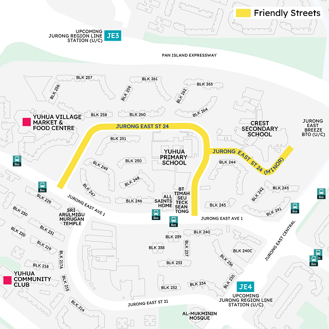
The Friendly Street at Jurong East Street 24 will make it easier for residents to visit key amenities such as Yuhua Village Market & Food Centre, Yuhua Primary School, Crest Secondary School, places of worship and All Saints Nursing Home.
Residents can look forward to new barrier-free crossings, and pedestrian priority with longer Green Man crossing time and shorter waiting times at pedestrian signalised crossings.

New barrier-free crossings with wider centre medians will make it easier for pedestrians to cross the road.

Street signs and green road surface markings will remind motorists to slow down when entering and driving along the Friendly Street.
Pek Kio

The Pek Kio Friendly Streets will serve the residents along Cambridge Road, Owen Road, and Kent Road, many of whom cross the roads regularly to visit the nearby Pek Kio Market.
Features such as a raised pedestrian crossing will allow a more seamless experience crossing the road, benefiting existing residents as well as future residents and young families in the upcoming public housing flats at Owen Road.

The existing pedestrian crossing across Owen Road will be raised and have longer Green Man crossing times, with green coloured road surfaces before the crossing . These new features will provide greater barrier-free and safer routes for residents to cross the road. The green road surface markings will remind motorists to slow down nearing the crossing.

The existing zebra crossing will be raised to allow pedestrians, especially young children and seniors, to be more visible to motorists when they cross the road.
Punggol

The Friendly Streets at Punggol Shore will serve residents going to nearby schools such as Horizon Primary School, Greendale Primary School and Greendale Secondary School, and amenities in the area such as Oasis Terraces, Punggol 21 Community Club and Punggol Plaza.

Residents can look forward to new signalised pedestrian crossings near Oasis Terraces and Punggol 21 Community Club which will make it easier for pedestrians to cross the road safely.

Street signs and green road surface markings will remind motorists to slow down when entering and driving along Friendly Streets.
Sembawang

The Sembawang Friendly Streets is located next to Sembawang station, covering Sembawang Drive, Sembawang Vista, Sembawang Alley, Sembawang Way and Admiralty Drive.

New barrier-free crossings with wider centre medians will make it easier for pedestrians to cross the road. A new bus-friendly hump will also make crossings safer by slowing down traffic.

Green road surface markings will remind motorists to slow down and look out for pedestrians when approaching crossings. Pedestrians will enjoy shorter waiting times and extended crossing times at signalised pedestrian crossings.
Tiong Bahru/Havelock

The Tiong Bahru/Havelock Friendly Streets will cover Havelock Road and Indus Road, which are widely used by residents in the neighbourhood to visit Beo Crescent Market and Havelock Road Cooked Food Centre.
Residents will be able to enjoy new barrier-free kerbless crossings and raised zebra crossings when this Friendly Streets is completed.

The existing zebra crossing across Havelock Road will be raised with green coloured road surfaces to make it barrier-free and safer for residents to cross the road. The green road surface markings will remind motorists to slow down and look out for pedestrians when approaching crossings.

Pedestrians will also enjoy shorter waiting and extended crossing times at the existing signalised pedestrian crossings.
News Releases
Construction for Friendly Streets Pilots Begins with Strong Community Support
Additional $1 Billion to Encourage More Walk Cycle Ride Journeys
Factsheet: Friendly Streets Pilot to Commence in Five Locations
Designing Friendly Streets and Repurposing Roads to Enhance Walk Cycle Ride Experiences


